Niagara Falls (Cayuga: Gahnawehtaˀ or Tgahnawęhtaˀ ) is the collective name for three waterfalls that straddle the the international border between the Canadian province of Ontario and the U.S. state of New York. They form the southern end of the Niagara Gorge.
From largest to smallest, the three waterfalls are the Horseshoe Falls, the American Falls and the Bridal Veil Falls. The Horseshoe Falls lie on the Canadian side and the American Falls on the American side, separated by Goat Island. The smaller Bridal Veil Falls are also located on the American side, separated from the other waterfalls by Luna Island. The international boundary line was originally drawn through Horseshoe Falls in 1819, but the boundary has long been in dispute due to natural erosion and construction.
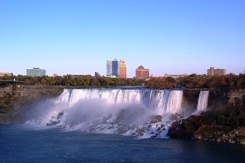
Located on the Niagara River which drains Lake Erie into Lake Ontario, the combined falls form the highest flow rate of any waterfall in the world, with a vertical drop of more than 165 feet (50 m). Horseshoe Falls is the most powerful waterfall in North America, as measured by vertical height and also by flow rate. The falls are located 17 miles (27 km) north-northwest of Buffalo, New York and 75 miles (121 km) south-southeast of Toronto, between the twin cities of Niagara Falls, Ontario, and Niagara Falls, New York.

Niagara Falls were formed when glaciers receded at the end of the Wisconsin glaciation (the last ice age), and water from the newly formed Great Lakes carved a path through the Niagara Escarpment en route to the Atlantic Ocean. While not exceptionally high, the Niagara Falls are very wide. More than 6 million cubic feet (168,000 m3) of water falls over the crest line every minute in high flow, and almost 4 million cubic feet (110,000 m3) on average.
The Niagara Falls are renowned both for their beauty and as a valuable source of hydroelectric power. Managing the balance between recreational, commercial, and industrial uses has been a challenge for the stewards of the falls since the 19th century.
Characteristics
The Horseshoe Falls drop about 173 feet (53 m), while the height of the American Falls varies between 70–100 feet (21–30 m) because of the presence of giant boulders at its base. The larger Horseshoe Falls are about 2,600 feet (790 m) wide, while the American Falls are 1,060 feet (320 m) wide. The distance between the American extremity of the Niagara Falls and the Canadian extremity is 3,409 feet (1,039 m).
The volume of water approaching the falls during peak flow season may sometimes be as much as 202,000 cubic feet (5,700 m3, 5.7 million liters) per second. Since the flow is a direct function of the Lake Erie water elevation, it typically peaks in late spring or early summer. During the summer months, 100,000 cubic feet (2,800 m3) per second of water actually traverses the falls, some 90% of which goes over the Horseshoe Falls, while the balance is diverted to hydroelectric facilities. This is accomplished by employing a weir with movable gates upstream from the Horseshoe Falls. The falls flow is further halved at night, and during the low tourist season in the winter, remains a flat 50,000 cubic feet (1,400 m3) per second. Water diversion is regulated by the 1950 Niagara Treaty and is administered by the International Niagara Board of Control (IJC).

American Falls (large waterfall on the left) and Bridal Veil Falls (smaller waterfall on the right)

Canadian Horseshoe falls as viewed from Skylon Tower.
Geology
The features that became Niagara Falls were created by the Wisconsin glaciation about 10,000 years ago. The same forces also created the North American Great Lakes and the Niagara River. All were dug by a continental ice sheet that drove through the area, deepening some river channels to form lakes, and damming others with debris. Scientists argue that there is an old valley, buried by glacial drift, at the approximate location of the present Welland Canal.
When the ice melted, the upper Great Lakes emptied into the Niagara river, which followed the rearranged topography across the Niagara Escarpment. In time, the river cut a gorge through the north facing cliff, or cuesta. Because of the interactions of three major rock formations, the rocky bed did not erode evenly. The top rock formation was composed of erosion-resistant limestone and Lockport dolostone. That hard layer of stone eroded more slowly than the underlying materials. The aerial photo on the right clearly shows the hard caprock, the Lockport Formation (Middle Silurian), which underlies the rapids above the falls, and approximately the upper third of the high gorge wall.
Immediately below the hard-rock formation, comprising about two thirds of the cliff, lay the weaker, softer, sloping Rochester Formation (Lower Silurian). This formation was composed mainly of shale, though it has some thin limestone layers. It also contains ancient fossils. In time, the river eroded the soft layer that supported the hard layers, undercutting the hard caprock, which gave way in great chunks. This process repeated countless times, eventually carving out the falls.

Aerial view of Niagara Falls, showing parts of Canada (left) and the United States (upper right).
About 10,900 years ago, the Niagara Falls was located between present-day Queenston, Ontario, and Lewiston, New York, but erosion of their crest has caused the waterfalls to retreat approximately 6.8 miles (10.9 km) southward. The Horseshoe Falls, which are approximately 2,600 feet (790 m) wide, have also changed their shape through the process of erosion; evolving from a small arch, to a horseshoe bend, to the present day gigantic inverted V. Just upstream from the falls' current location, Goat Island splits the course of the Niagara River, resulting in the separation of the Canadian Horseshoe Falls to the west from the American and Bridal Veil Falls to the east. Engineering has slowed erosion and recession.
History
There are differing theories as to the origin of the name of the falls. According to Iroquoian scholar Bruce Trigger, "Niagara" is derived from the name given to a branch of the locally residing native Neutral Confederacy, who are described as being called the "Niagagarega" people on several late 17th century French maps of the area. According to George R. Stewart, it comes from the name of an Iroquois town called "Ongniaahra", meaning "point of land cut in two". Henry Schoolcraft reported:
"Niagara Falls. This name is Mohawk. It means, according to Mrs. Kerr, the neck; the term being first applied to the portage or neck of land, between lakes Erie and Ontario. By referring to Mr. Elliott's vocabulary, (chapter xi) it will be seen that the human neck, that is, according to the concrete vocabulary, his neck, is onyara. Red Jacket pronounced the word Niagara to me, in the spring of 1820, as if written O-ne-au-ga-rah."
1837 woodcut of Falls, from États Unis d'Amérique by Roux de Rochelle.
During the 18th century, tourism became popular, and by mid-century, it was the area's main industry. Napoleon Bonaparte's brother Jérôme visited with his bride in the early 19th century. In 1837 during the Caroline affair a rebel supply ship, the Caroline, was burned and sent over the falls. In March 1848, ice blockage caused the falls to stop; no water (or at best a trickle) fell for as much as 40 hours. Waterwheels stopped, mills and factories simply shut down for having no power. Later that year demand for passage over the Niagara River led to the building of a footbridge and then Charles Ellet's Niagara Suspension Bridge. This was supplanted by German-born John Augustus Roebling's Niagara Falls Suspension Bridge in 1855. After the American Civil War, the New York Central railroad publicized Niagara Falls as a focus of pleasure and honeymoon visits. With increased railroad traffic, in 1886, Leffert Buck replaced Roebling's wood and stone bridge with the predominantly steel bridge that still carries trains over the Niagara River today. The first steel archway bridge near the falls was completed in 1897. Known today as the Whirlpool Rapids Bridge, it carries vehicles, trains, and pedestrians between Canada (through Canadian Customs Border Control) and the U.S.A. just below the falls. In 1912 much of the water coming over the American Falls froze, though there was still a trickle and the falls ran at the other two sites.

Man and woman on Canadian side of Niagara Falls, circa 1858
After the First World War, tourism boomed again as automobiles made getting to the falls much easier. The story of Niagara Falls in the 20th century is largely that of efforts to harness the energy of the falls for hydroelectric power, and to control the development on both sides that threaten the area's natural beauty.
A team from the U.S. Army Corp of Engineers dammed the falls in June 1969 in order to clear rock from the base of the falls. Rockslides had caused a significant buildup of rock at the bottom of the American side of the falls, and the engineers were to clean up the rock and repair some faults to prevent eventual erosion of the American side of the waterfall. A temporary dam was constructed to divert the flow of water to the Canadian side; the dam measured 600 feet (180 m) across and was made of nearly 30,000 tons of rock. The engineers cleared the rock debris and tested for safety, finishing the project in November of that year. The temporary dam was blown up to restore water flow.
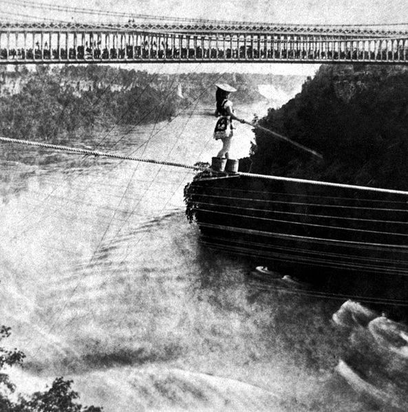
Maria Spelterini crossing the Niagara gorge on a tightrope on July 8, 1876
Before the late 20th century the northeastern end of the Horseshoe Falls was in the United States, flowing around the Terrapin Rocks, which was once connected to Goat Island by a series of bridges. In 1955 the area between the rocks and Goat Island was filled in, creating Terrapin Point. In the early 1980s the United States Army Corps of Engineers filled in more land and built diversion dams and retaining walls to force the water away from Terrapin Point. Altogether 400 feet (120 m) of the Horseshoe Falls was eliminated, including 100 feet (30 m) on the Canadian side. According to author Ginger Strand, the Horseshoe Falls is now entirely in Canada. Other sources say "most of" Horseshoe Falls is in Canada.
Impact on industry and commerce
Power
The enormous energy of Niagara Falls has long been recognized as a potential source of power. The first known effort to harness the waters was in 1759, when Daniel Joncaire built a small canal above the falls to power his sawmill. Augustus and Peter Porter purchased this area and all of American Falls in 1805 from the New York state government, and enlarged the original canal to provide hydraulic power for their gristmill and tannery. In 1853, the Niagara Falls Hydraulic Power and Mining Company was chartered, which eventually constructed the canals which would be used to generate electricity. In 1881, under the leadership of Jacob Schoellkopf, Niagara River's first hydroelectric generating station was built. The water fell 86 feet (26 m) and generated direct current electricity, which ran the machinery of local mills and lit up some of the village streets.
The Niagara Falls Power Company, a descendant of Schoellkopf's firm, formed the Cataract Company headed by Edward Dean Adams, with the intent of expanding Niagara Falls power capacity. In 1890, a five-member International Niagara Commission headed by Sir William Thomson among other distinguished scientists deliberated on the expansion of Niagara hydroelectric capacity based on seventeen proposals, but could not select any as the best combined project for hydraulic development and distribution. When Nikola Tesla, for whom a memorial was later built at Niagara Falls, New York, U.S.A., invented the three-phase system of alternating current power transmission, distant transfer of electricity became possible, as Westinghouse and Tesla had built the AC-power Ames Hydroelectric Generating Plant and proved it effective. In 1893, Westinghouse Electric was hired to design a system to generate alternating current on Niagara Falls, and three years after that, the world's first large AC power system was created, activated on August 26, 1895. The Adams Power Plant Transformer House remains as a landmark of the original system.
By 1896, with financing from moguls like J.P. Morgan, John Jacob Astor IV, and the Vanderbilts, they had constructed giant underground conduits leading to turbines generating upwards of 100,000 horsepower (75 MW), and were sending power as far as Buffalo, 20 miles (32 km) away. Some of the original designs for the power transmission plants were created by the Swiss firm Faesch & Piccard, which also constructed the original 5,000HP waterwheels.

Hydroelectric power dam at the Robert Moses Generating facility, Lewiston, New York.
Private companies on the Canadian side also began to harness the energy of the falls. The Government of the province of Ontario, Canada eventually brought power transmission operations under public control in 1906, distributing Niagara's energy to various parts of the Canadian province.
Other hydropower plants were also being built along the Niagara River. But in 1956, disaster struck when the region's largest hydropower station was partially destroyed in a landslide. The landslide drastically reduced power production and tens of thousands of manufacturing jobs were at stake. In 1957, Congress passed the Niagara Redevelopment Act, which granted the New York Power Authority the right to fully develop the United States' share of the Niagara River's hydroelectric potential.
In 1961, when the Niagara Falls hydroelectric project first went on line, it was the largest hydropower facility in the Western world. Today, Niagara is still the largest electricity producer in New York State, with a generating capacity of 2.4 gigawatts (million kilowatts). Up to 375,000 U.S. gallons (1,420 m3) of water a second is diverted from the Niagara River through conduits under the City of Niagara Falls to the Lewiston and Robert Moses power plants. Currently between 50% and 75% of the Niagara River's flow is diverted via four huge tunnels that arise far upstream from the waterfalls. The water then passes through hydroelectric turbines that supply power to nearby areas of Canada and the United States before returning to the river well past the falls. This water spins turbines that power generators, converting mechanical energy into electrical energy. When electricity demand is low, the Lewiston units can operate as pumps to transport water from the lower bay back up to the plant's reservoir, allowing this water to be used again during the daytime when electricity use peaks. During peak electrical demand, the same Lewiston pumps are reversed and actually become generators, similar to those at the Moses plant.
To preserve Niagara Falls' natural beauty, a 1950 treaty signed by the U.S. and Canada limited water usage by the power plants. The treaty allows higher summertime diversion at night when tourists are fewer and during the winter months when there are even fewer tourists. This treaty, designed to ensure an "unbroken curtain of water" is flowing over the falls, states that during daylight time during the tourist season (April 1st to October 31st) there must be 100,000 cubic feet per second (2,800 m3/s) of water flowing over the falls, and during the night and off-tourist season there must be 50,000 cubic feet per second (1,400 m3/s) of water flowing over the falls. This Treaty is monitored by the International Niagara Control Board. During winter the Power Authority of New York works with Ontario Power Generation, to prevent ice on the Niagara River from interfering with power production or causing flooding of shoreline property. One of their joint efforts is an 8,800-foot (2,700 m)–long ice boom, which prevents the buildup of ice, yet allows water to continue flowing downstream.
The most powerful hydroelectric stations on the Niagara River are the Sir Adam Beck 1 and 2 on the Canadian side and the Robert Moses Niagara Power Plant and the Lewiston Pump Generating Plant on the American side. Together, Niagara's generating stations can produce about 4.4 gigawatts of power.
In August 2005 Ontario Power Generation, which is responsible for the Sir Adam Beck stations, announced plans to build a new 6.5 miles (10.5 km) tunnel to tap water from farther up the Niagara river than is possible with the existing arrangement. The project is expected to be completed in 2009, and will increase Sir Adam Beck's output by about 182 megawatts (4.2%).
Transport
Ships can bypass Niagara Falls by means of the Welland Canal, which was improved and incorporated into the Saint Lawrence Seaway in the middle 1950s. While the seaway diverted water traffic from nearby Buffalo and led to the demise of its steel and grain mills, other industries in the Niagara River valley flourished with the help of the electric power produced by the river. However, since the 1970s the region has declined economically.

The cities of Niagara Falls, Ontario, Canada and Niagara Falls, New York, U.S.A. are connected by two international bridges. The Rainbow Bridge, just downriver from the falls, affords the closest view of the falls and is open to non-commercial vehicle traffic and pedestrians. The Whirlpool Rapids Bridge lies one mile (1.6 km) north of the Rainbow Bridge and the oldest bridge over the Niagara River. Nearby Niagara Falls International Airport and Buffalo Niagara International Airport were named after the waterfall, as were Niagara University, countless local businesses, and even an asteroid.
Preservation efforts
Niagara Falls has long been a source of inspiration for explorers, travelers, artists, authors, filmmakers, residents and visitors, few of whom realize that the falls were nearly to be solely devoted to industrial and commercial use. In the 1870s, sightseers had limited access to Niagara Falls and often had to pay merely for a glimpse, and industrialization threatened to carve up Goat Island in an effort to further expand commercial development. Other industrial encroachments and lack of public access led to a conservation movement in the U.S. known as Free Niagara, led by such notables as Hudson River school artist Frederic Edwin Church, landscape designer Frederick Law Olmsted, and architect Henry Hobson Richardson. Mr Church approached Lord Dufferin, governor-general of Canada, with a proposal for international discussions on the establishment of a public park.

Niagara Fälle. Les chûtes du Niagara. Niagara Falls (circa 1832): aquatint by Karl Bodmer from the book "Maximilian, Prince of Wied’s Travels in the Interior of North America, during the years 1832–1834"

Albert Bierstadt's oil painting of Niagara Falls
In 1887, Olmsted and Calvert Vaux issued a supplemental report detailing plans to restore the falls. Their intent was "to restore and conserve the natural surroundings of the Falls of Niagara, rather than to attempt to add anything thereto", and the report anticipated fundamental questions. How would preservationists provide access without destroying the beauty of the falls? How would they restore natural landscapes damaged by man? They planned a park with scenic roadways, paths and a few shelters designed to protect the landscape while allowing large numbers of visitors to enjoy the falls. Commemorative statues, shops, restaurants, and a 1959 glass and metal observation tower were added later. Preservationists continue to strive to strike a balance between Olmsted's idyllic vision, and the realities of administering a popular scenic attraction.
Preservation efforts continued well into the 20th century. J. Horace McFarland, the Sierra Club, and the Appalachian Mountain Club persuaded the United States Congress in 1906 to enact legislation to preserve the falls by regulating the waters of Niagara River. The act sought, in cooperation with the Canadian government, to restrict diversion of water, and a treaty resulted in 1909 that limited the total amount of water diverted from the falls by both nations to approximately 56,000 cubic feet (1,600 m3) per second. That limitation remained in effect until 1950.
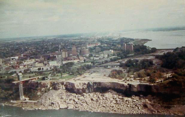
American Falls "shut off" during erosion control efforts in 1969
Commercial interests have continued to encroach on the land surrounding the state park, including the construction of several tall buildings (most of them hotels) on the Canadian side. The result is a significant alteration and urbanisation of the landscape. One study indicated it has caused the airflow near the falls to change direction. Students at the University of Guelph demonstrated, using scale models, that as air passes over the top of the new hotels it causes a breeze to roll down the south sides of the buildings and spill into the gorge below the falls, where it feeds into a whirlpool of moisture and air. The inference was that a documented rise in the number of "mist days" was a result of these breezes, where mist days refers to the mist plume of the falls reaching landside. In 1996 there were 29 mist days recorded, but by 2003 that number had risen to 68. Another study has discounted this opinion and linked mist production primarily to the difference in air and water temperature at the falls. However, this study does not offer opinion as to why mist days have been increasing just that the hotel breezes are an unlikely cause.
Over the falls
In October 1829, Sam Patch, who called himself "the Yankee Leapster", jumped from a high tower into the gorge below the falls and survived; this began a long tradition of daredevils trying to go over the falls.

Bobby Leach and his barrel after his trip over Niagara Falls, 1911
Jumps and plunges
On October 24, 1901, 63-year-old Michigan school teacher Annie Edson Taylor was the first person to go over the falls in a barrel as a publicity stunt; she survived, bleeding, but virtually unharmed. Soon after exiting the barrel, she said, "No one ought ever do that again." Prior to Taylor's attempt, on October 19 a domestic cat named Iagara was sent over the Horseshoe Falls in her barrel to test its strength. Contrary to rumours at the time, the cat survived the plunge unharmed and later posed with Taylor in photographs. Since Taylor's historic ride, 14 people have intentionally gone over the falls in or on a device, despite her advice. Some have survived unharmed, but others have drowned or been severely injured. Survivors of such stunts face charges and stiff fines, as it is illegal, on both sides of the border, to attempt to go over the falls.
In 1918, there was a near disaster when a barge, known locally as the Niagara Scow, working upriver broke its tow, and almost plunged over the falls. Fortunately, the two workers on board saved themselves by grounding the vessel on rocks just short of the falls.
Englishman Captain Matthew Webb, the first man to swim the English Channel, drowned in 1883 trying to swim the rapids down river from the falls.
In the "Miracle at Niagara", Roger Woodward, a seven-year-old American boy, was swept over the Horseshoe Falls protected only by a life vest on July 9, 1960, as two tourists pulled his 17-year-old sister Deanne from the river only 20 feet (6 m) from the lip of the Horseshoe Falls at Goat Island. Minutes later, Woodward was plucked from the roiling plunge pool beneath the Horseshoe Falls after grabbing a life ring thrown to him by the crew of the Maid of the Mist boat.
On July 2, 1984, Canadian Karel Soucek from Hamilton, Ontario successfully plunged over the Horseshoe Falls in a barrel with only minor injuries. Soucek was fined $500 for performing the stunt without a license. In 1985, he was fatally injured while attempting to re-create the Niagara drop at the Houston Astrodome. His aim was to climb into a barrel hoisted to the rafters of the Astrodome and to drop 180 feet (55 m) into a water tank on the floor. After his barrel released prematurely, it hit the side of the tank and he died the next day from his injuries.
In August 1985, Steve Trotter, an aspiring stunt man from Rhode Island, became the youngest person ever (age 22) and the first American in 25 years to go over the falls in a barrel. Ten years later, Trotter went over the falls again, becoming the second person to go over the falls twice and survive. It was also the second-ever "duo"; Lori Martin joined Trotter for the barrel ride over the falls. They survived the fall but their barrel became stuck at the bottom of the falls, requiring a rescue.
On September 28, 1989, Niagara's own Peter DeBernardi (age 42) and Jeffery James Petkovich (age 25) became the first "team" to successfully make it over the falls in a two-person barrel. The stunt was conceived by Peter DeBenardi, who wanted to discourage youth from following in his path of addictive drug use. Peter was also trying to leave a legacy and discourage his son Kyle Lahey DeBernardi (age 2) from using addictive drugs. Peter DeBernardi had initially planned to have a different passenger. However, Peter's original partner backed out, and Peter was forced to look for an alternative. Jeffery Petkovich agreed to attempt the stunt with him. Peter claims he spent an estimated $30,000 making his barrel, made of steel and fiberglass, which had harnesses, reinforcing steel bands, and viewing ports. Peter's barrel also had a radio for music and news reports, rudders to help steer the barrel through the falls, oxygen, and a well-protected video camera to record the journey over the edge. They emerged shortly after going over with minor injuries and were charged with performing an illegal stunt under the Niagara Parks Act.
On September 27, 1993 John "David" Munday, of Caistor Centre, Ontario, became the first known person to survive going over the falls twice.
Kirk Jones of Canton, Michigan became the first known person to survive a plunge over the Horseshoe Falls without a flotation device on October 20, 2003. While it is still not known whether Jones was determined to commit suicide, he survived the 16-story fall with only battered ribs, scrapes, and bruises.
A second person survived an unprotected trip over the Horseshoe Falls on March 11, 2009 and when rescued from the river, was reported to be suffering from severe hypothermia and a large wound to his head. His identity has not been released. Eyewitnesses reported seeing the man intentionally enter the water.
On May 21, 2012, an unidentified man in his early 40s became the third person to survive an unprotected trip over the Horseshoe Falls. Eyewitness reports indicate that he "deliberately jumped" into the Niagara River after climbing over a railing.
Walks
Other daredevils have made crossing the gorge their goal, starting with the successful passage by Jean François "Blondin" Gravelet, who crossed Niagara Gorge in 1859. Between 1859 and 1896 there was a wire-walking craze, and there were frequent feats over the river below the falls. One inexperienced walker was able to slide down his safety rope. Only one man fell to his death, at night and under mysterious circumstances, at the anchoring place for his wire.

Blondin carrying his manager, Harry Colcord, on a tightrope.
These tightrope walkers drew huge crowds to witness their exploits. Their wires ran across the gorge, near the current Rainbow Bridge, not over the waterfall itself. Among the many was Ontario's William Hunt, who billed himself as "The Great Farini" and competed with Blondin in performing outrageous stunts over the gorge. On three separate occasions Blondin carried his manager, Harry Colcord, on his back – on the final time being watched by the Prince of Wales.
Maria Spelterina walking a tightrope across Niagara Gorge, from the United States to Canada, with her feet in peach baskets, 1876.

Nik Wallenda crossing over Niagara Falls in 2012
On June 15, 2012, high wire artist Nik Wallenda became the first person to walk across the falls in 116 years, after receiving special permission from both governments. The full length of his tightrope was 1,800 feet (550 m). Wallenda crossed near the brink of the Horseshoe Falls, unlike previous walkers who had crossed farther downstream. According to Wallenda, it was the longest unsupported tightrope walk in history. He carried his passport on the trip and was required to present it upon arrival on the Canadian side of the falls.
Other entertainment
Movies and television
lready a huge tourist attraction and favorite spot for honeymooners, Niagara Falls visits rose sharply in 1953 after the release of Niagara, a movie starring Marilyn Monroe and Joseph Cotten. Later in the 20th century, the falls was a featured location in 1980s movie Superman II, and was itself the subject of a popular IMAX movie, Niagara: Miracles, Myths and Magic. Much of the episode Return of the Technodrome in the 1987 Teenage Mutant Ninja Turtles cartoon series take place near the Niagara Falls and its hydroelectric plant. Illusionist David Copperfield performed a trick in which he appeared to travel over the Horseshoe Falls in 1990. The falls, or more particularly, the tourist-supported complex near the Falls, was the setting of the short-lived Canadian television show Wonderfalls in early 2004. More recently, location footage of the falls was shot in October 2006 to portray "World's End" of the movie Pirates of the Caribbean: At World's End.
Music
Composer Ferde Grofe was commissioned by the Niagara Falls Power Generation project in 1960 to compose the Niagara Falls Suite in honor of the completion of the first stage of hydroelectric work at the falls. Each movement is dedicated to the falls, or to the history of the greater Buffalo region.
Literature
The Niagara Falls area features as the base camp for a German aerial invasion of the United States in the H. G. Wells novel The War in the Air.
Fine art

Louis Rémy Mignot, Niagara, Brooklyn Museum

Arthur Parton, Niagara Falls, Brooklyn Museum
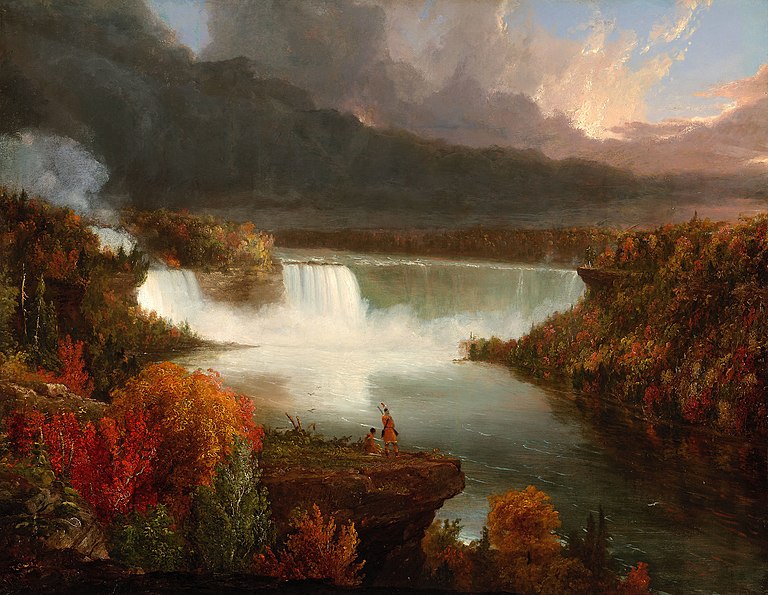
Thomas Cole, Distant View of Niagara Falls 1830, Art Institute of Chicago

Alvan Fisher, A General View of the Falls of Niagara, 1820, The Smithsonian Institution
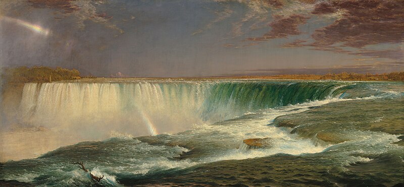
Frederic Edwin Church, Niagara Falls, 1857, Corcoran Gallery of Art, Washington, DC.

William Morris Hunt, Niagara Falls, 1878
Tourism
Peak visitor traffic occurs in the summertime, when Niagara Falls are both a daytime and evening attraction. From the Canadian side, floodlights illuminate both sides of the falls for several hours after dark (until midnight). The number of visitors in 2007 was expected to total 20 million and by 2009, the annual rate was expected to top 28 million tourists.
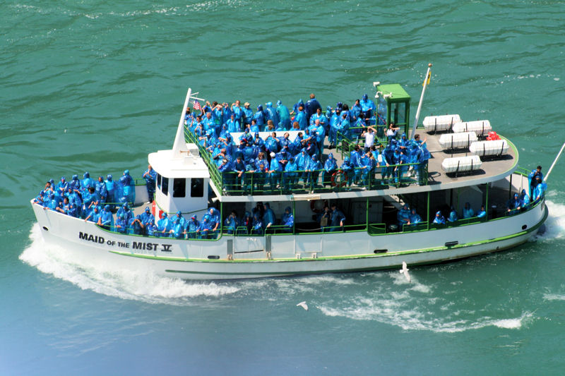
The oldest and best known tourist attraction at Niagara Falls is the Maid of the Mist boat cruise, named for an ancient Ongiara Indian mythical character, which has carried passengers into the rapids immediately below the falls since 1846. Cruise boats operate from boat docks on both sides of the falls.
American side
From the U.S. side, the American Falls can be viewed from walkways along Prospect Point Park, which also features the Prospect Point Park observation tower and a boat dock for the Maid of the Mist. Goat Island offers more views of the falls and is accessible by foot and automobile traffic by bridge above the American Falls. From Goat Island, the Cave of the Winds is accessible by elevator and leads hikers to a point beneath Bridal Veil Falls. Also on Goat Island are the Three Sisters Islands, the Power Portal where a huge statue of Nikola Tesla can be seen, and a walking path which enables views of the rapids, the Niagara River, the gorge, and all of the falls. Most of these attractions lie within the Niagara Falls State Park.
The Niagara Scenic Trolley offers guided trips along the American Falls and around Goat Island. Panoramic and aerial views of the falls can also be viewed from the Flight of Angels helium balloon ride, or by helicopter. The Niagara Gorge Discovery Center showcases the natural and local history of Niagara Falls and the Niagara Gorge. A casino and luxury hotel was opened in Niagara Falls, New York, by the Seneca Indian tribe. The Seneca Niagara Casino occupies the former Niagara Falls Convention Center. The new hotel is the first addition to the city's skyline since completion of the United Office Building in the twenties.

Niagara Falls at night

American Falls from the American side
Maid Of the Mist Tour

Cave Of the Winds Tour
The turbulent Cave of the Winds creates conditions similar to a hurricane.
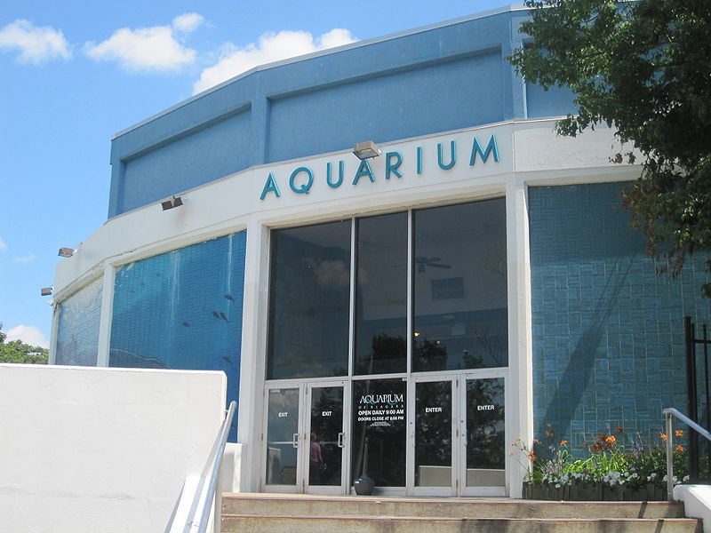
Niagara Falls State Park maintains a small aquarium.

Niagara Center with aerial view from the top floor

Trolley service is offered throughout Niagara Falls State Park.
The American side of the Falls and Bridal Veil Falls taken from the Canadian side.
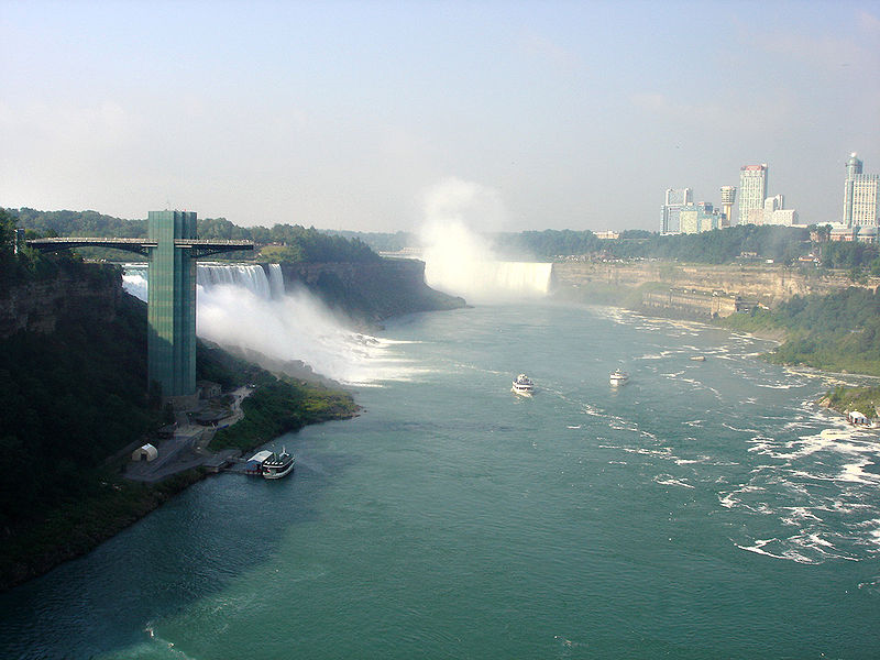
The Skylon Tower
On the Canadian side, Queen Victoria Park features manicured gardens, platforms offering spectacular views of both the American and Horseshoe Falls, and underground walkways leading into observation rooms which yield the illusion of being within the falling waters. The observation deck of the nearby Skylon Tower offers the highest overhead view of the falls, and in the opposite direction gives views as far as distant Toronto. Along with the Minolta Tower (formerly the Seagrams Tower and the Konica Minolta Tower, now called the Tower Hotel), it is one of two towers in Canada with a view of the falls.
Along the Niagara River, the Niagara River Recreational Trail runs the 35 miles (56 km) from Fort Erie to Fort George, and includes many historical sites from the War of 1812.
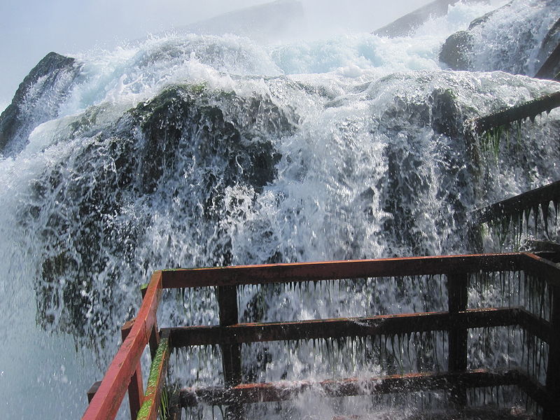
The Whirlpool Aero Car, built in 1916 from a design by Spanish engineer Leonardo Torres y Quevedo, is a cable car which takes passengers over the Niagara Whirlpool on the Canadian side. The Journey Behind the Falls — accessible by elevators from the street level entrance – consists of an observation platform and series of tunnels near the bottom of the Horseshoe Falls on the Canadian side.
There are two casinos on the Canadian side of Niagara Falls, the Niagara Fallsview Casino Resort and Casino Niagara. The former is situated in the Fallsview Tourist Area, alongside many of the area's hotels, whilst the latter is adjacent to Clifton Hill, on Falls Avenue, a major tourist promenade.

Canadian side

American and Bridal Falls on a full moon as seen from the Canadian side

American Falls and the Bridal Veil Falls from Maid of the Mist

The Horseshoe from helicopter

View of the Horseshoe from a Fallsview hotel room

Niagara Falls rapids (White water walk, Canadian side)

Observation platform of the Journey Behind the Falls below Table Rock
View from the Rainbow Bridge

Looking over the brink of Horseshoe Falls at night

Looking over the brink of Horseshoe Falls during the day